Kaipara Air Weapons Range (KAWR)
Military Operating Area M103 is going to be activated Sea Level to 2000 feet for the following activity. 
DANGER NOTICE
NZ DEFENCE LIVE FIRING ACTIVITY
The Kaipara Air Weapons Range will be activated on the 16-18th of September 2024 from 0800 – 2300 (8:00 am – 11:00pm).  The New Zealand Defence Force will be conducting Small Arms Live Firing during this period. The area concerned is the land and sea at South Kaipara Head contained within a 4500 metre radius circle centred on a position 36 degrees 28 minutes 45.3 seconds South and 174 degrees 9 minutes 38.1 seconds East (also known as area M103). The area will be marked by flags on the beach and road access, which will be patrolled. For their safety the Public are WARNED to stay well clear of the area during the periods of activation.

Public Announcements from Manulife Investment Management Forest Management NZ

WOODHILL FOREST PUBLIC ACCESS EASEMENT PARTIAL CLOSURE FROM 12 AUGUST 2024 TO 21 AUGUST 2024, AND BEYOND 21 AUGUST 2024
SITUATION:
Harvest Unit 3944 next to Coast Road will be felled and harvested from 4am 12 August 2024 to 5pm 21 August 2024, making it unsafe for the public to enter.
The Department of Conservation has issued the following notice in October 2022:
We are advising that the public access easement at Tasman and Rimmer Road,/ Muriwai Beach, Auckland, is current closed to members of the public due to safety concerns.
This means there is currently no public access across the land privately owned by Ngā Maunga Whakahii o Kaipara to Muriwai Beach.
The Department is currently in discussion with other agencies and interested parties to address the ongoing maintenance and management of the public access easement.
All correspondence is to be emailed to [email protected].
We thank members of the public for respecting the easement closures during this period.
We asked the public to report all emergencies to FENZ (fire)  or NZ Police (111) and all suspicious behaviour to 027 535 5770.
PUBLIC ACCESS EASEMENT STATUS FROM 4 AM 12 AUGUST 2024 to 5PM 21 AUGUST 2024:
Easement
 Date from
 Date to
  Status
Tasman Road
6pm 10-Feb-23 
 Until further notice. 
Closed for safety of public access easement users.
(PAE No 1 Section D 4.2 & 4.3).
Winter rainfall damage to Tasman Road
makes it unsafe for open public use.
The landowners are in discussion with the Department of Conservation.
Rimmer Road
3-Oct-22 
 Until further notice. 
Closed for safety of public access easement users.
(PAE No 2, Section D 4.2 & 4.3).
The weather events have narrowed the road pavement,
making it unsafe for open public use.
The landowners are in discussion with
the Department of Conservation.
Coast Road
 4am 12 August 2024 
 5pm 21 August 2024.  
 Closed for safety of public access easement users.
 (PAE No 3, Section D 4.2 & 4.3).
 NO ACCESS IS PERMITTED ON COAST ROAD AT ANY TIME.
 
PUBLIC ACCESS EASEMENT STATUS FROM 5PM 21 AUGUST 2024 forwards:
Easement
 Date from
 Date to
  Status
Tasman Road
6pm 10-Feb-23 
 Until further notice.
Closed for safety of public access easement users.
(PAE No 1 Section 4.2 & 4.3).
Winter rainfall damaged to Tasman Road
makes it unsafe for open public use.
The landowners are in discussion with
the Department of Conservation.
Rimmer Road
3-Oct-22 
 Until further notice. 
Closed for safety of public access easement users.
(PAE No 2, Section D 4.2 & 4.3).
The weather events have narrowed the road pavement,
making it unsafe for open public use.
The landowners are in discussion with
the Department of Conservation.
Coast Road
5pm 21 August 2024 
 Until further notice.  
Closed for safety of public access easement users.
(PAE No 3, Section D 4.2 & 4.3).
Only walk in access on Coast Road to access
Muriwai Regional Park (5 Mile) is permitted.

Please remember

  1. Additional to the above, there is no public access permitted into Woodhill Forest beyond the open Public Access Easement roads, and no public access (by any means) beyond to the east of Coast Road, or north of Old Telephone Track.
    Reason: the land is private property. Contact 09 420 9566 for more information.
  2. VEHICLES LOCKED IN MUST CALL SECURITY ON 0275355770, and PAY THE NIGHT GATE OPEN CHARGE.
  3. Auckland Council Regional Parks manage access to the 5-mile strip (Muriwai Regional Park).
Any changes to the Public Access Easement access will be published by Thursday 4 pm during a given week or when conditions change.
Signage will be displayed at the start of the easements.

Te Ngahere o Woodhill is an operational forest on private land.

Woodhill is a working forest. Forestry operations are constant and ongoing, and the location of operations changes frequently. Consequently, authorised access to the forest is only approved via our permitting and deconflicting processes to ensure the safety of all staff, operators, and visitors.

This excludes access to the licensed recreational operators in Te Ngahere o Woodhill – see
Activities

  • No public access (other than to the recreational parks – see Activities)
  • All authorised access and activity is by permit only.
  • The NZDF bombing range, at the northern tip of the South Head peninsula, is not part of the forest.
  • No motorised access is permitted over or on the dunes other than on the 4WD beach access, when it is safe to use, from the 10-mile carpark at the end of the Rimmer Road public access easement – currently closed to members of the public due to safety concerns (enquiries to [email protected])
  • The unloading of unregistered and/or unwarranted motorbikes or off-road vehicles from the Rimmer Road 10-mile carpark is not permitted – currently closed to members of the public due to safety concerns (enquiries to [email protected])
  • Hunting is managed by the Woodhill Fallow Management Council. You can apply for a ballot on their website www.fallowdeer.co.nz.
  • No fires/smoking in the forest or the dunes.
  • No camping
  • Check the notices section on this web page
  • Phone the forest information line +64 9 420 9566 ext. 0
  • Phone the forest office during business hours 9 am to 5 pm Monday to Friday +64 9 420 9566

There is no public access to the forest.

Forest Kaitiaki/Wardens are patrolling the forest. If you are found in the forest without a permit, you will be asked to leave and risk being trespassed.

In the event of an emergency and if you see or smell smoke call 111.

INFORMATION

For further information regarding events and current restrictions phone +64 9 4209566.
If you witness any suspicious activity in the forest or on the beach, please phone the Police 105 line.

AFTER HOURS

If you need to contact us after hours regarding an incident in Woodhill Forest that requires an immediate response from our Company (i.e., a matter of urgency that cannot wait until the next business day), please phone 021 128 4550 to reach the after-hours duty manager.

In an EMERGENCY dial 111.

Kaipara Air Weapons Range (KAWR)
Military Operating Area M103 is going to be activated Sea Level to 2000 feet for the following activity. 
DANGER NOTICE
NZ DEFENCE LIVE FIRING ACTIVITY
The Kaipara Air Weapons Range will be activated on the 16-18th of September 2024 from 0800 – 2300 (8:00 am – 11:00pm).  The New Zealand Defence Force will be conducting Small Arms Live Firing during this period. The area concerned is the land and sea at South Kaipara Head contained within a 4500 metre radius circle centred on a position 36 degrees 28 minutes 45.3 seconds South and 174 degrees 9 minutes 38.1 seconds East (also known as area M103). The area will be marked by flags on the beach and road access, which will be patrolled. For their safety the Public are WARNED to stay well clear of the area during the periods of activation.

Public Announcements from Manulife Investment Management Forest Management NZ

WOODHILL FOREST PUBLIC ACCESS EASEMENT PARTIAL CLOSURE FROM 12 AUGUST 2024 TO 21 AUGUST 2024, AND BEYOND 21 AUGUST 2024
SITUATION:
Harvest Unit 3944 next to Coast Road will be felled and harvested from 4am 12 August 2024 to 5pm 21 August 2024, making it unsafe for the public to enter.
The Department of Conservation has issued the following notice in October 2022:
We are advising that the public access easement at Tasman and Rimmer Road,/ Muriwai Beach, Auckland, is current closed to members of the public due to safety concerns.
This means there is currently no public access across the land privately owned by Ngā Maunga Whakahii o Kaipara to Muriwai Beach.
The Department is currently in discussion with other agencies and interested parties to address the ongoing maintenance and management of the public access easement.
All correspondence is to be emailed to [email protected].
We thank members of the public for respecting the easement closures during this period.
We asked the public to report all emergencies to FENZ (fire)  or NZ Police (111) and all suspicious behaviour to 027 535 5770.
PUBLIC ACCESS EASEMENT STATUS FROM 4 AM 12 AUGUST 2024 to 5PM 21 AUGUST 2024:
Easement
 Date from
 Date to
  Status
Tasman Road
6pm 10-Feb-23 
 Until further notice. 
Closed for safety of public access easement
users.
(PAE No 1 Section D 4.2 & 4.3).
Winter rainfall damage to Tasman Road
makes it unsafe for open public use.
The landowners are in discussion with the
Department of Conservation.
Rimmer Road
3-Oct-22 
 Until further notice. 
Closed for safety of public access easement
users.
(PAE No 2, Section D 4.2 & 4.3).
The weather events have narrowed the
road pavement, making it
unsafe for open public use.
The landowners are in discussion with
the Department of Conservation.
Coast Road
 4am 12 August 2024 
 5pm 21 August 2024.  
Closed for safety of public access easement
users.
(PAE No 3, Section D 4.2 & 4.3).
NO ACCESS IS PERMITTED ON COAST ROAD
AT ANY TIME
.
 
PUBLIC ACCESS EASEMENT STATUS FROM 5PM 21 AUGUST 2024 forwards:
Easement
 Date from
 Date to
  Status
Tasman Road
6pm 10-Feb-23 
 Until further notice.
Closed for safety of public access easement
users.
(PAE No 1 Section 4.2 & 4.3).
Winter rainfall damaged to Tasman Road
makes it unsafe for open public use.
The landowners are in discussion with
the Department of Conservation.
Rimmer Road
3-Oct-22 
 Until further notice. 
Closed for safety of public access easement
users.
(PAE No 2, Section D 4.2 & 4.3).
The weather events have narrowed the
road pavement, making it
unsafe for open public use.
The landowners are in discussion with
the Department of Conservation.
Coast Road
5pm 21 August 2024 
 Until further notice.  
Closed for safety of public access easement
users.
(PAE No 3, Section D 4.2 & 4.3).
Only walk in access on Coast Road to access
Muriwai Regional Park (5 Mile) is permitted.

Please remember

  1. Additional to the above, there is no public access permitted into Woodhill Forest beyond the open Public Access Easement roads, and no public access (by any means) beyond to the east of Coast Road, or north of Old Telephone Track.
    Reason: the land is private property. Contact 09 420 9566 for more information.
  2. VEHICLES LOCKED IN MUST CALL SECURITY ON 0275355770, and PAY THE NIGHT GATE OPEN CHARGE.
  3. Auckland Council Regional Parks manage access to the 5-mile strip (Muriwai Regional Park).
Any changes to the Public Access Easement access will be published by Thursday 4 pm during a given week or when conditions change.
Signage will be displayed at the start of the easements.

WOODHILL FOREST INFORMATION LINE:
09 420 9566 ext. 0

FYI

If you need to contact us after hours regarding an incident in Woodhill Forest that requires an immediate response from our Company (i.e. a matter of urgency that cannot wait until the next business day), please phone 021 128 4550 to reach the after-hours duty manager. In an EMERGENCY dial 111.
Manulife Investment Management Forest Management (NZ) Ltd 09 470 1300 or 09 283 9019 after hours.

NZDF Base Ops Whenuapai 09 417 7442.

If you witness any suspicious activity, please phone the Crimestoppers line at 0800-555-111, report the incident on the police 105 line, or report the incident to forest security at 027 535 5770.

Vehicles left in the forest after hours will be towed at the owner’s expense or a release fee will be charged by security:

Security Contact Details

  • First Security –  0800 347 787 (Restall Road gate)
  • Forest security – 027 535 5770 (Rimmer Road and Tasman Road gates)

The Muriwai Rangers manage access to the Muriwai Regional Park (5-mile strip).
To contact the Muriwai Rangers phone 09 369 5829.

Woodhill Forest land to the east of Coast Road and north of Old Telephone Track is private property. Trespassers will be prosecuted.

Kaipara Air Weapons Range (KAWR)
Military Operating Area M103 is going to be activated Sea Level to 2000 feet for the following activity. 
DANGER NOTICE
NZ DEFENCE LIVE FIRING ACTIVITY
The Kaipara Air Weapons Range will be activated on the 16-18th of September 2024 from 0800 – 2300 (8:00 am – 11:00pm).  The New Zealand Defence Force will be conducting Small Arms Live Firing during this period. The area concerned is the land and sea at South Kaipara Head contained within a 4500 metre radius circle centred on a position 36 degrees 28 minutes 45.3 seconds South and 174 degrees 9 minutes 38.1 seconds East (also known as area M103). The area will be marked by flags on the beach and road access, which will be patrolled. For their safety the Public are WARNED to stay well clear of the area during the periods of activation.

Public Announcements from Manulife Investment Management Forest Management NZ

WOODHILL FOREST PUBLIC ACCESS EASEMENT PARTIAL CLOSURE FROM 12 AUGUST 2024 TO 21 AUGUST 2024, AND BEYOND 21 AUGUST 2024
SITUATION:
Harvest Unit 3944 next to Coast Road will be felled and harvested from 4am 12 August 2024 to 5pm 21 August 2024, making it unsafe for the public to enter.
The Department of Conservation has issued the following notice in October 2022:
We are advising that the public access easement at Tasman and Rimmer Road,/ Muriwai Beach, Auckland, is current closed to members of the public due to safety concerns.
This means there is currently no public access across the land privately owned by Ngā Maunga Whakahii o Kaipara to Muriwai Beach.
The Department is currently in discussion with other agencies and interested parties to address the ongoing maintenance and management of the public access easement.
All correspondence is to be emailed to [email protected].
We thank members of the public for respecting the easement closures during this period.
We asked the public to report all emergencies to FENZ (fire)  or NZ Police (111) and all suspicious behaviour to 027 535 5770.
PUBLIC ACCESS EASEMENT STATUS FROM 4 AM 12 AUGUST 2024 to 5PM 21 AUGUST 2024:
Easement
 Date from
 Date to
  Status
Tasman Road
6pm 10-Feb-23 
 Until further notice. 
Closed for safety of public access easement
users.
(PAE No 1 Section D 4.2 & 4.3).
Winter rainfall damage to Tasman Road
makes it unsafe for open public use.
The landowners are in discussion with the
Department of Conservation.
Rimmer Road
3-Oct-22 
 Until further notice. 
Closed for safety of public access easement
users.
(PAE No 2, Section D 4.2 & 4.3).
The weather events have narrowed the
road pavement, making it
unsafe for open public use.
The landowners are in discussion with
the Department of Conservation.
Coast Road
 4am 12 August 2024 
 5pm 21 August 2024.  
Closed for safety of public access easement
users.
(PAE No 3, Section D 4.2 & 4.3).
NO ACCESS IS PERMITTED ON COAST ROAD
AT ANY TIME
.
 
PUBLIC ACCESS EASEMENT STATUS FROM 5PM 21 AUGUST 2024 forwards:
Easement
 Date from
 Date to
  Status
Tasman Road
6pm 10-Feb-23 
 Until further notice.
Closed for safety of public access easement
users.
(PAE No 1 Section 4.2 & 4.3).
Winter rainfall damaged to Tasman Road
makes it unsafe for open public use.
The landowners are in discussion with
the Department of Conservation.
Rimmer Road
3-Oct-22 
 Until further notice. 
Closed for safety of public access easement
users.
(PAE No 2, Section D 4.2 & 4.3).
The weather events have narrowed the
road pavement, making it
unsafe for open public use.
The landowners are in discussion with
the Department of Conservation.
Coast Road
5pm 21 August 2024 
 Until further notice.  
Closed for safety of public access easement
users.
(PAE No 3, Section D 4.2 & 4.3).
Only walk in access on Coast Road to access
Muriwai Regional Park (5 Mile) is permitted.

Please remember

  1. Additional to the above, there is no public access permitted into Woodhill Forest beyond the open Public Access Easement roads, and no public access (by any means) beyond to the east of Coast Road, or north of Old Telephone Track.
    Reason: the land is private property. Contact 09 420 9566 for more information.
  2. VEHICLES LOCKED IN MUST CALL SECURITY ON 0275355770, and PAY THE NIGHT GATE OPEN CHARGE.
  3. Auckland Council Regional Parks manage access to the 5-mile strip (Muriwai Regional Park).
Any changes to the Public Access Easement access will be published by Thursday 4 pm during a given week or when conditions change.
Signage will be displayed at the start of the easements.

The Restall Road gate to access the horse park

  • This gate is normally open from 6.30 am and closed at 6 pm in winter and 8 pm in summer.
    Summer hours begin and end with daylight saving.

No riding on forest land outside of the horse park boundary and the approved trails that are conditionally accessible south of the horse park.
Riders found in any other areas of the forest will be trespassed.

Vehicles left in the forest after hours will be towed at the owner’s expense or a release fee will be charged by forest security.

Security Contact Details:

  • First Security – 0800 347 787 (Restall Road gate)
  • Black Hawk Security – 027 535 5770 (Rimmer Road gate)

COAST ROAD PUBLIC ACCESS EASEMENT

Coast Road is permanently closed to motorised vehicle access.
Access by foot, bicycle or horse is permitted during daylight hours.

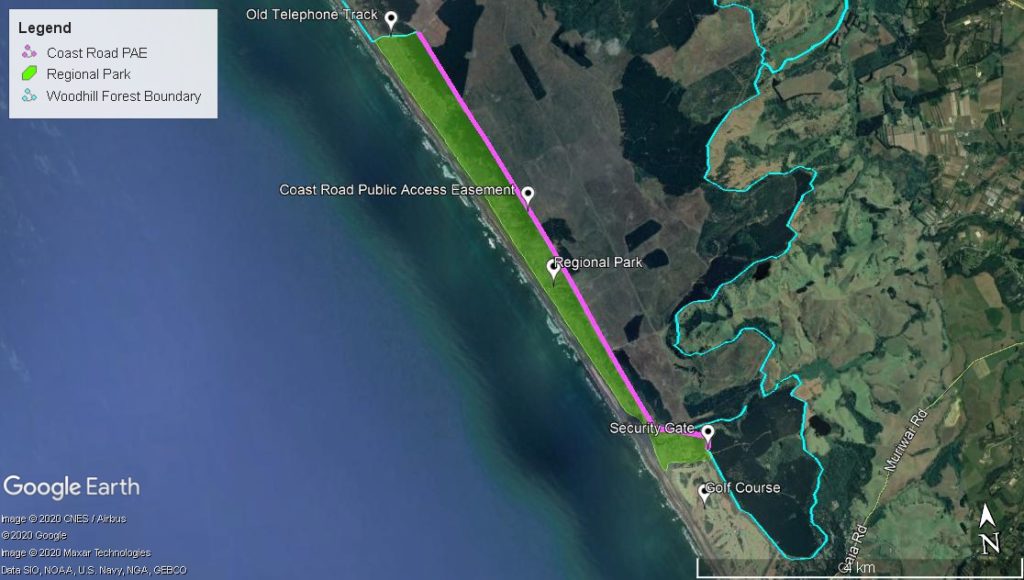
There is no access permitted into Woodhill Forest beyond the formation of the Coast Road public access easement, from the Coast Road security gate to Old Telephone Track.
Woodhill Forest land to the east of Coast Road and north of Old Telephone Track is private property, trespassers will be prosecuted.

There is public access from the easement to the Muriwai Regional Park. The regional park is west of Coast Road and south of Old Telephone Track.
Auckland Council Regional Parks (Muriwai Rangers) manage access to the 5-mile strip (Muriwai Regional Park).
To contact the Muriwai Rangers phone 09 369 5829.

Any changes to Public Access Easement access will be published on this website and on the Woodhill Forest Information Line 09 420 9566 ext. 0.

FYI

If you need to contact us after hours regarding an urgent incident in Woodhill Forest, that cannot wait until the next business day, please phone 021 128 4550 to reach the After Hours Duty Manager. In an EMERGENCY dial 111.

Manulife Investment Management Forest Management (NZ) Ltd 09 470 1300 or 09 283 9019 after hours.

Muriwai Rangers 09 369 5829

If you witness any suspicious activity in the forest or on the beach, please phone the Crimestoppers line on 0800-555-111 or report the incident on 09-839-0600.

09 420 9566 ext. 1 – reception

09 420 9566 ext. 0 (forest info line)

[email protected]

71 Restall Road, RD 3, Waimauku 0883 map

P O Box 315, Kumeū 0841

For further contact details please click here

PUBLIC NOTICE (2016)

In 2013 Ngā Maunga Whakahii o Kaipara (NMWoK, the ‘corporate’ entity representing Ngāti Whātua o Kaipara) purchased the land under Woodhill Forest from the Crown as part of our Treaty of Waitangi settlement. The land then became privately owned. The primary reason for purchasing the land was a commercial investment to fund the hapū’s social, educational, cultural and health programmes.

As private land, there is no obligation on NMWoK to provide access to the public – just as there is no public right to roam on the private land any of us own, our homes.

Ngāti Whātua o Kaipara has for centuries now welcomed new people into our region – even when for periods of time we became marginalised and dispossessed. We understand and value the development of a strong community and will play our part. The various activities we run or licence within Woodhill (e.g. Woodhill Mountain Bike Park, Tree Adventures, off-roading, dirt biking, paintball) give opportunities to the public to enjoy the forest – whilst contributing to the commercial return we expected when we decided to purchase it. However unquestionably the most significant activity in the forest is forestry, which we both licence and now, increasingly, participate in as a joint venture partner. Forestry is a high-risk industry and the forest is a workplace. Other mobile businesses such as firewood collection also use the forest. One-off events are increasingly common. There is even a live-firing weapons range at the northern end of the forest and military exercises at times outside of that area. We have strict obligations on us as the landowner, landlord and now forestry company to keep this workplace, and all within it, safe as required under legislation. The new health and safety legislation that came into force this year (2016) is much tighter than the old and sets out massive penalties for our senior staff and board members should an incident occur and our processes are found lacking. This encourages caution. We know other organisations with similar responsibilities to us are grappling with how to manage their obligations in a sensible way. You may well see a range of responses but no-one wants to be the test case in a prosecution under the new legislation. Our tenant businesses are as conscious as we are of their organisational risks operating in the forest. We need to take their concerns into account in how we manage the forest.

So, for now, having taken legal advice, discussed these matters in depth with our tenants and business partners, and considering our own appetite for risk (especially those in positions of authority for us who would face fines into the millions should we be convicted of a failing under health and safety legislation), our cautious position is that the public may only access Woodhill Forest by permit, or in one of the licenced activity areas. For horse-riders, this means the exclusive horse park area, the boundary of which is described as the ‘perimeter trail’ on your maps. As registered riders, we know we have your details should we need to contact you. We know you have been informed of the dangers in the forest and made aware of where to find information on changing situations in the forest (e.g. areas that are out of bounds because of harvesting activity). We know the area within which you will be found (and importantly where you should not be, but where we could then permit other activity).  The same can be said of all the other licensed activities we sanction in the forest. This knowledge and ability to exert control and keep things safe are absent when we don’t know who is in the forest, doing what and where. Managing this mosaic of use takes a lot of staff time and attention – and so there is a cost to this. There is also a limit to the complexity of use that we believe we can actually keep track of, across all 12,500 hectares of the forest, and keep everyone within safe to a reasonable standard. Only we out of all the businesses/groups/individuals that access and use the forest can appreciate, and need to know, everything that is happening in it every day. Thus, we reserve the right to only permit what we believe we can safely manage. We will continue to make use of tools like media, signage, pamphlets, our kaitiaki educators and trespass, to discharge our responsibilities and preserve our own rights.

Constructive feedback is welcome, but we will continue to take a precautionary approach that allows us to feel we are discharging our duty of care to ourselves and our workers, our tenants and business partners, and our customers. Over time we will make changes to the forest regime as experience, understanding and the mosaic of activities change. Some of these may be less restrictive, and some may prove to need to be more restrictive.

It would be easy (and tempting) to discuss and debate public access in the forest forever, but we are loathed to endlessly revisit this. Now and again we will respond if there is something new to be added or clarified but generally, we hope and trust that people will respect us as a private landowner and business. We know we won’t meet the wants of all the wider public who would like to have unfettered access to the forest, but this posting sets out again why we are acting as we are. We will take note of reasonable suggestions but will generally consider these in our own way and time as we manage the large, complex beast that is Woodhill Forest.

  • A wind monitoring mast will be installed at the southern end of Woodhill forest. A second mast location has also been consented but at this stage there are no plans to erect a second mast
  • The mast will be in place until enough data has been gathered, which may be up to four years.
  • Ngā Maunga Whakahii o Kaipara (NMWoK) is receiving a rental for the placement of the wind monitoring mast on the land.
  • Foundation construction will begin next month (June) and the mast is expected to be in place by end of July. Prep and construction work will be preceded by appropriate Ngāti Whātua ceremony, and ground disturbing activity will be monitored.
  • The wind monitoring mast will be 80 m tall and 22.5 cm in diameter. While it will be able to be seen from a distance, it will appear as a thin line and in most conditions barely visible. Installing wind monitoring masts is standard practice in the early stages of investigating the potential of a new wind farm development site.
  • Reweti Marae reps and community have been approached for opinion on the installation of the wind test mast (as the closest marae) and are supportive.
  • The actual development of a wind farm would be a separate process from wind monitoring and there has been no pre-determination that NMWoK and Meridian would proceed to develop a wind farm, even if the wind resource proves to be good.
  • For NMWoK the decision to allow the development of a wind farm in the future would require consideration of cultural, environmental, social and financial impacts. These will be considered during the period of time that wind monitoring is being carried out.
  • Should a wind farm be developed in the future, there will be a consent process to be followed that will include stakeholder engagement.
  • Any future wind farm would only occupy a small proportion of what is now forest and there are many ancillary activities that could take place under and around wind turbines, both existing and new (e.g. recreational pursuits such as mountain biking, alternative crops and bee-keeping, grazing, events etc.).

About Meridian:

Meridian is the largest generator of electricity in New Zealand and only generates from renewable energy sources. They own and operate five wind farms across New Zealand, and six hydro power generation stations (the Manapouri power station in Fiordland and five hydro power stations on the Waitaki River). They retain a portfolio of new generation development options ready to be advanced when the market requires. Meridian is also a retailer of electricity to more than 217,000 homes and businesses across New Zealand.