


Kaipara Air Weapons Range (KAWR)
DANGER NOTICE
NZ DEFENCE LIVE EXPLOSIVE DEMOLITION ACTIVITY
The Kaipara Air Weapons Range will be activated for (Daily Live Firing Hours from 0730 – 1800 on 06-09 July 2026). The New Zealand Defence Force will be conducting Live Firing exercise during this period. The area concerned is the land and sea at South Kaipara Head contained within a 4500-metre radius circle centred on a position 36 degrees 28 minutes 45.3 seconds South and 174 degrees 9 minutes 38.1 seconds East (also known as area M103). The area will be marked by flags on the beach and road access, which will be patrolled. For their safety, the Public are WARNED to stay well clear of the area during the periods of activation.
The following roads are CLOSED for Forest access during the activity period : Lone Pine Track, Inland Rd, Tasman Rd and Lagoon Rd from 06 – 09 July 2026.
For any enquires please contact Whenuapai Base Operations 09 417 7442 (24/7).
Kaipara Air Weapons Range (KAWR)
DANGER NOTICE
NZ DEFENCE LIVE EXPLOSIVE DEMOLITION ACTIVITY
The Kaipara Air Weapons Range will be activated for (35 Hours of Live Firing Hours from 0700 on 01 July – 1800 on 02 July 2026). The New Zealand Defence Force will be conducting Live Firing exercise during this period. The area concerned is the land and sea at South Kaipara Head contained within a 4500-metre radius circle centred on a position 36 degrees 28 minutes 45.3 seconds South and 174 degrees 9 minutes 38.1 seconds East (also known as area M103). The area will be marked by flags on the beach and road access, which will be patrolled. For their safety, the Public are WARNED to stay well clear of the area during the periods of activation.
The following roads are CLOSED for Forest access during the activity period : Lone Pine Track, Inland Rd, Tasman Rd and Lagoon Rd from 30 June – 02 July 2026.
For any enquires please contact Whenuapai Base Operations 09 417 7442 (24/7).
A Message from Auckland Council
As our normal reminder, if you are driving on the beach, please make sure you keep your speed down (stick to the speed limits), keep your distance from others, and acquaint yourself with the skills you need to drive on a beach, including having the right tyre pressure and equipment and being aware of the tide cycle and swell states. Please stay out of the dunes, the Defence area, and the forest – it is private property.
We would ask for your continued help reporting dangerous driving and driving in prohibited areas (like the dunes and the forest). Please report the matter immediately to the police.
If lives are at risk or someone is in imminent danger, call 111. For non-urgent incidents or events after the fact, make a report online via 105.police.govt.nz, or call 105. Please help us to keep the beach safe for everyone by reporting bad driving behaviours.
Lastly, do not light any fires, as these have always been prohibited on Te Oneone Rangatira / Muriwai Beach. Dry conditions present a significantly heightened risk to the forest and surrounding area.
A Message from NZ Police
A reminder that vehicle access to the beach requires a permit. To obtain your permit to drive on the beach, please click on the following link, which only takes five minutes and is free of charge:
Apply online for a beach driving permit for Muriwai and Karioitahi beaches
Public Announcements from Manulife Investment Management Forest Management NZ
The Department of Conservation has issued the following notice in October 2022:
We are advising that the public access easement at Tasman and Rimmer Road,/ Muriwai Beach, Auckland, is currently closed to members of the public due to safety concerns.
This means there is currently no public access to Muriwai Beach across the land privately owned by Ngā Maunga Whakahii o Kaipara.
The Department is currently discussing with other agencies and interested parties how to address the ongoing maintenance and management of the public access easement.
All correspondence is to be emailed to [email protected].
We thank members of the public for respecting the easement closures during this period.
We asked the public to report all emergencies to FENZ (fire) or NZ Police (111) and all suspicious behaviour to 027 535 5770.
Public Access Easement status from 5 pm on 21 August 2024
Easement |
Date from |
Date to |
Status |
Tasman Road |
6 pm 10-Feb-23 |
Until further notice. |
Closed for the safety of public access easement users.
|
Rimmer Road |
3-Oct-22 |
Until further notice. |
Closed for the safety of public access easement users.
|
Coast Road |
5 pm 21-Aug-24 |
Until further notice. |
Walk-in access only on Coast Road
|
Please remember
-
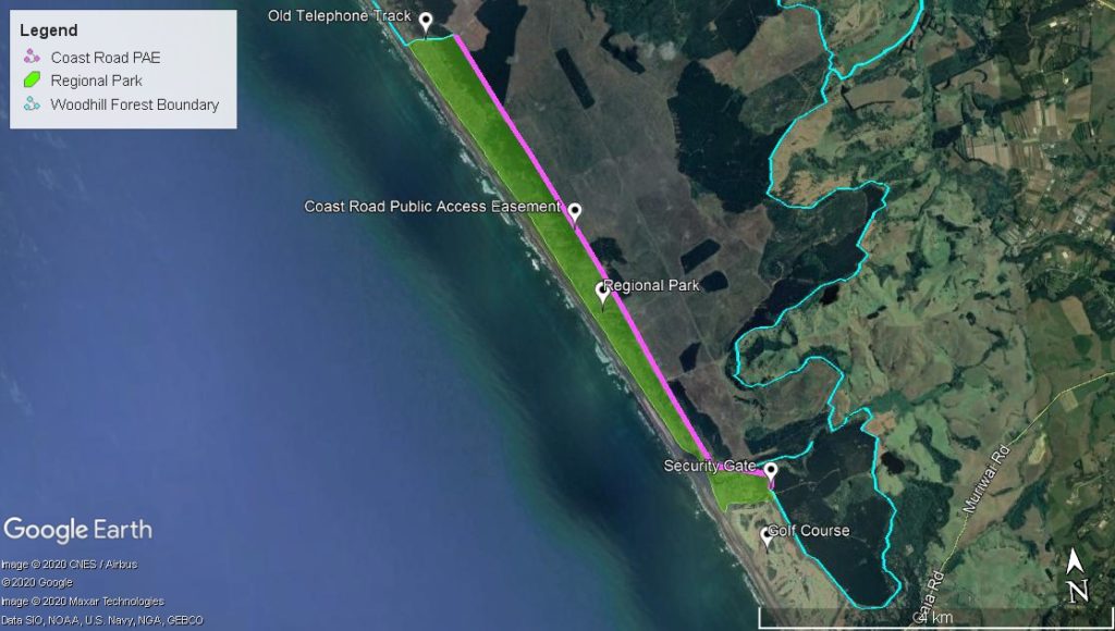
In addition to the above, no public access is permitted into Woodhill Forest beyond the open Public Access Easement roads and no public access (by any means) east of Coast Road or north of Old Telephone Track.
Reason: the land is private property. Contact 09 420 9566 for more information. -
VEHICLES LOCKED IN MUST CALL SECURITY ON 0275355770, and PAY THE NIGHT GATE OPEN CHARGE.
-
Auckland Council Regional Parks manage access to the 5-mile strip (Muriwai Regional Park).
Any changes to the Public Access Easement access will be published by Thursday at 4 pm during a given week or when conditions change.
Signage will be displayed at the start of the easements.
Access and Use of Te Ngahere o Woodhill
Te Ngahere o Woodhill is a private, operational forest with ongoing forestry activities. Due to the constantly changing nature of these operations, access is strictly controlled through a permitting and deconfliction process to ensure the safety of all staff, operators, and visitors.
Access Restrictions
Public access without a permit is prohibited except for accessing the licensed recreational operators (see Activities).
-
- All authorised access and activities require a permit.
- The NZDF bombing range at the northern tip of the South Head peninsula is not part of the forest.
- Motorised access over or on the dunes is prohibited.
- The Woodhill Fallow Management Council manages hunting. Apply for a ballot at www.fallowdeer.co.nz.
Prohibited Activities
-
- No fires or smoking in the forest or dunes. No camping.
Forest Access & Safety
-
- Forest Information Line: +64 9 420 9566 ext. 0
- Forest Office – +64 9 420 9566
Monday to Friday, 9:30 am to 2:30 pm. - No public access to the forest without a permit.
- Forest Kaitiaki/Wardens patrol the area. Anyone found without a permit will be asked to leave and may face trespassing action.
- Call 105 to report non-emergency incidents at the forest or beach to the police.
- EMERGENCY – call 111 immediately
After Hours Contact
For urgent matters requiring an immediate response
-
- Call the after-hours duty manager at 021 128 4550.
Security Contact Details
-
- First Security – 0800 347 787 (Restall Road gate)
- Forest security – 027 535 5770 (Rimmer Road and Tasman Road gates)
The Muriwai Rangers
Manage the Muriwai Regional Park (5-mile strip)
-
- 09 301 0101
Woodhill Forest land east of Coast Road and north of Old Telephone Track is private property.
A Message from Auckland Council
As our normal reminder, if you are driving on the beach, please make sure you keep your speed down (stick to the speed limits), keep your distance from others, and acquaint yourself with the skills you need to drive on a beach, including having the right tyre pressure and equipment and being aware of the tide cycle and swell states. Please stay out of the dunes, the Defence area, and the forest – it is private property.
I would ask for your continued help reporting dangerous driving and driving in prohibited areas (like the dunes and the forest). Please report the matter immediately to the police.
If lives are at risk or someone is in imminent danger, call 111. For non-urgent incidents or events after the fact, make a report online via 105.police.govt.nz, or call 105. Please help us to keep the beach safe for everyone by reporting bad driving behaviours.
Lastly, do not light any fires, as these have always been prohibited on Te Oneone Rangatira / Muriwai Beach. Dry conditions present a significantly heightened risk to the forest and surrounding area.
A Message from NZ Police
A reminder that vehicle access to the beach requires a permit. To obtain your permit to drive on the beach, please click on the following link, which only takes five minutes and is free of charge:
Apply online for a beach driving permit for Muriwai and Karioitahi beaches
Public Announcements from Manulife Investment Management Forest Management NZ
The Department of Conservation has issued the following notice in October 2022:
We are advising that the public access easement at Tasman and Rimmer Road,/ Muriwai Beach, Auckland, is currently closed to members of the public due to safety concerns.
This means there is currently no public access to Muriwai Beach across the land privately owned by Ngā Maunga Whakahii o Kaipara.
The Department is currently discussing with other agencies and interested parties how to address the ongoing maintenance and management of the public access easement.
All correspondence is to be emailed to [email protected].
We thank members of the public for respecting the easement closures during this period.
We asked the public to report all emergencies to FENZ (fire) or NZ Police (111) and all suspicious behaviour to 027 535 5770.
PUBLIC ACCESS EASEMENT STATUS FROM 5 PM 21 AUGUST 2024 forwards:
Easement |
Date from |
Date to |
Status |
Tasman Road |
6 pm 10-Feb-23 |
Until further notice. |
Closed for the safety of public access easement users.
|
Rimmer Road |
3-Oct-22 |
Until further notice. |
Closed for the safety of public access easement users.
|
Coast Road |
5 pm 21-Aug-24 |
Until further notice. |
Walk-in access only on Coast Road
|
Please remember
-
In addition to the above, no public access is permitted into Woodhill Forest beyond the open Public Access Easement roads and no public access (by any means) east of Coast Road or north of Old Telephone Track.
Reason: the land is private property. Contact 09 420 9566 for more information. -
VEHICLES LOCKED IN MUST CALL SECURITY ON 0275355770 and PAY THE NIGHT GATE OPEN CHARGE.
-
Auckland Council Regional Parks manage access to the 5-mile strip (Muriwai Regional Park).
Any changes to the Public Access Easement access will be published by Thursday 4 pm during a given week or when conditions change.
Signage will be displayed at the start of the easements.
Access and Use of Te Ngahere o Woodhill
Te Ngahere o Woodhill is a private, operational forest with ongoing forestry activities. Due to the constantly changing nature of these operations, access is strictly controlled through a permitting and deconfliction process to ensure the safety of all staff, operators, and visitors.
Access Restrictions
Public access without a permit is prohibited except for accessing the licensed recreational operators (see Activities).
-
- All authorised access and activities require a permit.
- The NZDF bombing range at the northern tip of the South Head peninsula is not part of the forest.
- Motorised access over or on the dunes is prohibited.
- Hunting is managed by the Woodhill Fallow Management Council. Apply for a ballot at www.fallowdeer.co.nz.
Prohibited Activities
-
- No fires or smoking in the forest or dunes. No camping.
Forest Access & Safety
-
- No public access to the forest without a permit.
- Forest Information Line: +64 9 420 9566 ext. 0
- Office – +64 9 420 9566
Monday to Friday, 9:30 am–2:30 pm (closed weekends and public holidays) - Forest Kaitiaki/Wardens patrol the area. Anyone found without a permit will be asked to leave and may face trespassing action.
- Call 105 to report non-emergency incidents at the forest or beach to the police.
- EMERGENCY – call 111 immediately
After Hours Contact
For urgent matters requiring an immediate response
-
- Call the after-hours duty manager at 021 128 4550.
Security Contact Details
-
- First Security – 0800 347 787 (Restall Road gate)
- Forest security – 027 535 5770 (Rimmer Road and Tasman Road gates)
The Muriwai Rangers
Manage the Muriwai Regional Park (5-mile strip)
-
- 09 369 5829
Woodhill Forest land east of Coast Road and north of Old Telephone Track is private property.
